Blog: Behind the Scenes as a Content Engineer
Trevor Wou, Content Engineer
Not everybody can say that their work involves creating and curating data that will be seen and used by millions of people, but as a Content Engineer at Vizzion, I can safely say that I do. From Microsoft’s integration of our service into Bing Maps and Windows 10, to the inclusion of camera feeds in broadcast traffic and weather reports from television stations across North America, our road imagery from locations in 43 countries is seen by a wide variety of users every day. Every single one of these cameras has been added, edited, and reviewed by a Content Engineer like me, and keeping our data set up to date and accurate is of paramount importance.

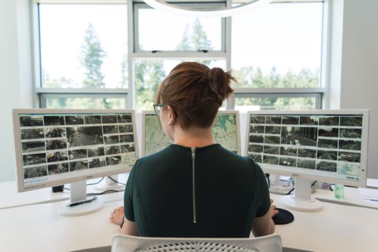
A Vizzion employee examines camera feeds in the Desktop Video Wall.
As the world’s largest traffic camera aggregator, Vizzion works closely with departments of transportation, governments, toll road operators, and private partners around the world to source imagery from road-facing cameras set up to monitor traffic conditions. We exclude red-light cameras, toll cameras, and other traffic enforcement tools from our data feed, but even then, our data set includes more than 65,000 roadside cameras. Installed by agencies mainly for the purpose of traffic supervision, our customers use our cameras for a wide variety of purposes, from validating road weather to disaster management to vehicle routing and dispatching.

Vizzion seamlessly brings together over 200 camera provider partners worldwide into a single data feed.
When I describe my job to people, they often assume that all I do is click through hundreds of images of highways per day. While that’s undeniably an aspect of my work, an average day as a Content Engineer consists of a variety of tasks, all of which contribute to the end goal of producing and maintaining a clean, orderly, and reliable data set. Each of us is assigned a geographic region – usually consisting either of multiple countries or multiple regions of larger countries such as the US. I usually begin my day by ensuring that all of my assigned regions are operating and up to date. Our automated status report shows which regions have been detected by our image analysis algorithms as out of service, so if one of my regions is reported as having technical issues, it’s my responsibility to investigate. Bringing a region back into service can be as simple as updating the feed for each out of service camera due to a change on the camera provider’s side, or it may involve informing Vizzion’s Sourcing Manager so they can reach out to the camera provider for more information.

Teamwork and peer review is important to ensure that camera data is as accurate as possible.
Once I’ve confirmed that all of my regions are operating properly, I work through the automatically generated list of regions that have been flagged by our system as containing new or modified camera feeds and see if any of my regions are included. If so, I’ll conduct a review of the region to confirm if there are new camera feeds and add them as well as keeping an eye out for any other changes in the data and updating accordingly. I’ll also conduct quality assurance reviews of regions which my colleagues have added; in order to sniff out any errors, all of our new regions are subjected to a secondary review by another Content Engineer before publication. New regions are added when our Sourcing Manager has secured access to cameras in a new area.
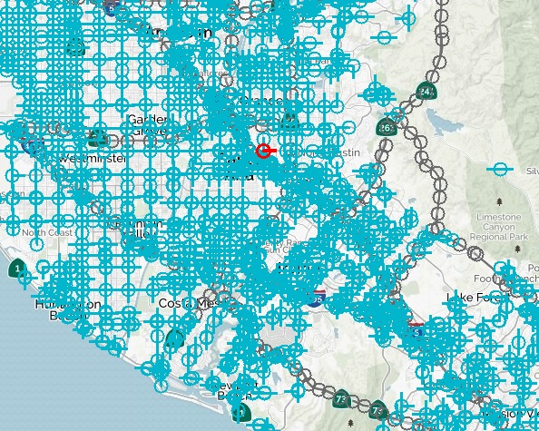
So far my focus has been on our roadside cameras, but Vizzion also provides access to a large number of on-vehicle cameras through a partnership with one of North America’s largest dashcam providers. We source images from these cameras via “hotspots”, which are virtual map points assigned to road segments that send us a snapshot from the vehicle camera every time one of our partner vehicles rolls over it. While the assignment of these hotspots is mostly automated, their names often require adjustments and locations may need slight tweaks. In order to achieve a satisfactory camera density, we often end up allocating hundreds of hotspots per day.

This map of Orange County, California shows the density at which we allocate “hotspots” to ensure maximum image collection from on-vehicle cameras.
Ensuring that all of the data you enter is of the highest quality can be repetitive and time-intensive, but there are other challenges associated with the job too. Vizzion’s worldwide coverage means that I have to deal with camera feeds from agencies and sources all around the world, many of which are not in English and use unfamiliar roadway abbreviations and terminology. It was also a challenge to learn the ins and outs of interacting with a data set as comprehensive and detailed as Vizzion’s. And of course, there’s the pressure that comes with being responsible for data that millions of people around the world use to avoid traffic, see road conditions, and even stay safe during natural disasters.
With all of these challenges, however, there come rewards. Through repetition comes expertise, and I’ve become proficient in adding camera feeds expediently with no cost to accuracy. I’ve also learned a number of interesting things through my deep dives into the transportation infrastructure of cities around the world which have required me to come up with clever new strategies and workarounds to keep our data consistent. Did you know, for example, that many small streets in Spain and Italy just don’t have names, or that cardinal directions in Montreal are skewed based on the St. Lawrence River (making Montreal’s “North” actually closer to Northwest)? These are just examples of the many problems we’ve solved over the years in creating a data set that’s consistent across over forty countries, forty-eight languages, and six continents. Combining disparate data sources, though, is one of the most satisfying parts of the job to me. Taking camera feeds from around the world with varying naming schemes, image and video formats, and visual layouts and consolidating them into one consistent feed is a rewarding experience.

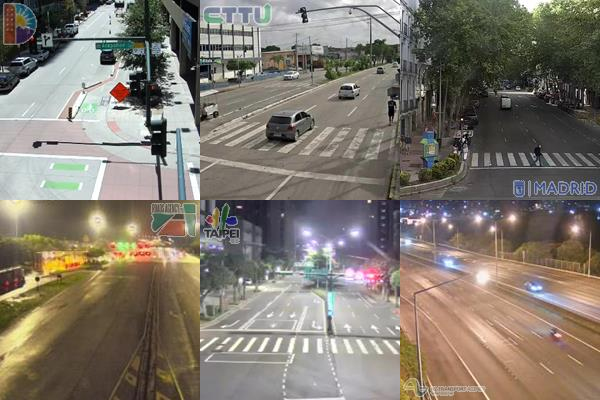
The sun never sets on Vizzion’s camera feed, as seen in this comparison of images from six continents.
There’s also more to the job than just adding and maintaining camera entries to our data set. A strong understanding of geography isn’t a requirement, but if you don’t have one when you start the job, you will by the time you’ve gotten the hang of things. From Albuquerque to Zagreb and everywhere in between, I’ve studied imagery of the streets looking for the precise locations of traffic cameras. We collect demographic and governmental details such as population, official language, and time zone for each region as well, and both official government websites and online encyclopedias such as Wikipedia are great sources of such information.
Vizzion guarantees a high degree of accuracy and precision in its data set to its customers, and as a Content Engineer, I’m one of the people responsible for maintaining that level of quality. Using an array of both off-the-shelf and proprietary tools, we ensure that the images and video streams that customers and end users receive work properly and include accurate metadata. It’s definitely a detail-oriented job to the extreme, but the end result is both a satisfying accomplishment and tremendously useful for users around the world.
About Vizzion
Vizzion is the leading provider of road imagery for traffic, weather, road condition, and safety operations and applications. Through partnerships with over 200 different transport agencies and on-vehicle camera providers, Vizzion offers live feeds from over 100,000 cameras in 40 countries across North America, Europe, Asia, Australasia, and key markets in South America and Africa. Both on-vehicle and roadside traffic camera services are available through Vizzion’s flexible API and turnkey Video Wall application. Vizzion’s content is trusted by major apps, map providers, broadcasters, fleets, and automotive organizations. Contact [email protected] for more information.